Mount St. Helens
Kurzinformation
inkl. MwSt. Versandinformationen
Artikel zZt. nicht lieferbar
Artikel zZt. nicht lieferbar

Beschreibung
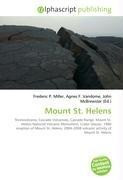
Mount St. Helens is an active stratovolcano located in Skamania County, Washington, in the Pacific Northwest region of the United States. It is 96 miles (154 km) south of Seattle and 50 miles (80 km) northeast of Portland, Oregon. Mount St. Helens takes its English name from the British diplomat Lord St Helens, a friend of explorer George Vancouver who made a survey of the area in the late 18th century. The volcano is located in the Cascade Range and is part of the Cascade Volcanic Arc, a segment of the Pacific Ring of Fire that includes over 160 active volcanoes. This volcano is well known for its ash explosions and pyroclastic flows. Mount St. Helens is most famous for its catastrophic eruption on May 18, 1980, at 8:32 am PDT which was the deadliest and most economically destructive volcanic event in the history of the United States. Fifty-seven people were killed; 250 homes, 47 bridges, 15 miles (24 km) of railways, and 185 miles (298 km) of highway were destroyed. The eruption caused a massive debris avalanche, reducing the elevation of the mountain's summit from 9,677 feet (2,950 m) to 8,365 feet (2,550 m) and replacing it with a 1 mile (1.6 km) wide horseshoe-shaped crater. von Miller, Frederic P.
Produktdetails

So garantieren wir Dir zu jeder Zeit Premiumqualität.
Über den Autor

- Hardcover
- 256 Seiten
- Erschienen 2022
- ISTE LTD
![Alpine Lakes Wilderness [mt. Baker-Snoqualmie and Okanogan-Wenatchee National Forests]: Trails Illustrated Other Rec. Areas (National Geographic Trails... Alpine Lakes Wilderness [mt. Baker-Snoqualmie and Okanogan-Wenatchee National Forests]: Trails Illustrated Other Rec. Areas (National Geographic Trails Illustrated Map, Band 825)](https://d3k2uuz9r025mk.cloudfront.net/media/image/1c/e5/00/1744790522_45757470590.jpg)
- map
- 1 Seiten
- Erschienen 2010
- NATL GEOGRAPHIC MAPS

- hardcover
- 236 Seiten
- Erschienen 1985
- Scottish Mountaineering Trust

- paperback -
- Erschienen 1986
- Mountain Pr

- map
- 1 Seiten
- Erschienen 2023
- swisstopo

- hardcover
- 126 Seiten
- Erschienen 1986
- Gallery Books

- paperback -
- Erschienen 1985
- Chronicle Books Llc


![swissBloc No. 1: Bouldertopo Schweiz [N] swissBloc No. 1: Bouldertopo Schweiz [N]](https://d3k2uuz9r025mk.cloudfront.net/media/image/9d/68/g0/1756215747_580409178234.jpg)


