


Great Smoky Mountains National Park Map
Kurzinformation
inkl. MwSt. Versandinformationen
Artikel zZt. nicht lieferbar
Artikel zZt. nicht lieferbar

Beschreibung
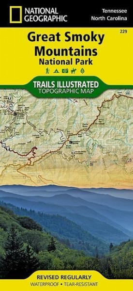
Detailed topographic map for Great Smoky Mountains National Park, with its endless forest that straddles the border between North Carolina and Tennessee, is the perfect recreational map for America's most visited national park. The map includes Great Smoky Mountains National Park in its entirety, the Appalachian Trail, Twentymile Trail, Lakeshore Trail, Chasteen Creek Trail, the Great Smoky Mountains, Chilowee Mountain, Little Mountain, the Blue Ridge Parkway, Cataloochee Divide, Pisgah National Forest, Cherokee National Forest, Nantahala National Forest, Little Tennessee River, Chilhowee Lake, Fontana Lake, Tuckasegee River, the cities of Maryville Tennessee, Gatlinburg Tennessee, Waynesville North Carolina, and more. Includes UTM grids for use with your GPS unit. von National Geographic Maps
Produktdetails

So garantieren wir Dir zu jeder Zeit Premiumqualität.


")
![Alpine Lakes Wilderness [mt. Baker-Snoqualmie and Okanogan-Wenatchee National Forests]: Trails Illustrated Other Rec. Areas (National Geographic Trails Illustrated Map, Band 825)](https://d3k2uuz9r025mk.cloudfront.net/media/image/1c/e5/00/1744790522_45757470590.jpg "Alpine Lakes Wilderness [mt. Baker-Snoqualmie and Okanogan-Wenatchee National Forests]: Trails Illustrated Other Rec. Areas (National Geographic Trails...")


")


")


")
")

")
")

")

")
")
")
")

")
")


")


")